Heit el-Ghurab
Forth Dynasty
Hannah Trevino
Introduction
The site I am doing is referred to in arabic as Heit el-Ghurab, in popular texts it has been referred to as the “Lost City of the Pyramid Builders” This site is said to be home to the people who built the pyramids most likely the pyramids of Khafre and Menkaure. The site includes many features one would find in a city, like bakeries, places for both the working class and elite to live and administration buildings. The city is surrounded by walls, on the western, southern and northern borders. There is evidence for administrative areas within the town, including house for administrators and the royal administration building. There is ample evidence for large of amounts of meat and fish processing that would have been used to feed the large amount of workers. This site offers insight into what an Egyptian would have looked like in 4th dynasty Egypt.
Geography and Location
The site itself sits on the Giza Plateau Southeast of Khafre's pyramid, almost directly south of the Sphinx. The site itself sits in low desert so it is probable that sand covered the area even when inhabited. Below the layer of sand there is a layer of gray soil referred to as mud mass, that is there due to the destructing of mudbrick walls. The Wall of the Crow is about 200m long. While the site lies about 10 kilometers away from the Nile, at the time of occupation it is thought that a rather large Nile channel flowed about kilometer east of Heit el-Ghurab. During excavation the archaeologists often struggled with problems of the water table being to high and having to control the water movement within the site with pumps. The southern part of the site has a soccer field lying over it which has caused problems with excavation of the Lagoon area. (1)(2)(4)
Site Description
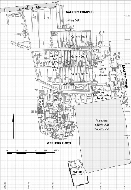
The Wall of the Crow is the northern border of the site. There is also an enclosure wall, which runs on the western and southern side of the settlement On the southern end of the site is a administrative building that houses large grain silos. The site takes up about 22 acres. This site was in occupation during the middle and late 4th dynasty. Using historical and archaeological data it has been concluded that these sites were abandoned after King Shepseskaf moved to Saqqara during the end of the 4th dynasty. (1)
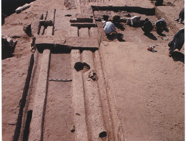
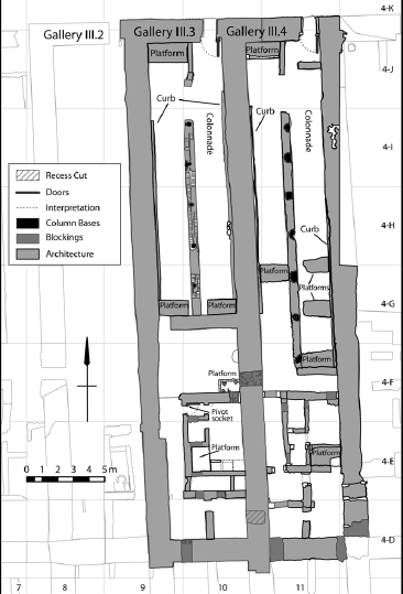
One of the main features of the sites are the galleries. Colonnades supported these galleries. In the southern ends of there galleries are private rooms. Most of the galleries have a sort of cooking space while only some have a living/sleeping quarters. The evidence for cooking in the southern portions of the house is prevalent in most of the galleries with large deposits of ash. There is also ample of evidence of bread mold sherds. Gallery III-4 was structured like a typical ancient egyptian house, a common public area in the front, a private living area and a cooking space in the back of the house. There is even evidence for bed platforms in the private part of the house. There is also a house at the excavation called a manor that is in the Gallery II area, which has evidence for being well decorated and being used for cooking purposes as well. Another prominent feature in the landscape is Hypostyle Hall, which could have been used as a dining area or some sort of grain/fish drying area. There were parallel troughs found in this building which are thought to have been for cleaning, salting and drying fish. The Royal Administration Building was also a prominent feature in the city, it has areas that could have been meeting rooms and also contains large grain silos, all of it cannot currently be accessed because it covered by a modern soccer field. This town was built in phases, many of the sites including the galleries and chute show evidence that there were predated structures they were built upon.. The enclosure wall was built after the wall of the Crow. Galley 1 was built upon the ruins of an earlier complex. The Royal Administration Building was also built closer to when the enclosure wall was built. (1)(2)
Excavation- History and Results
The excavation of the site began in 1988 with the launch of the Giza Plateau Mapping Project started be Mark Lehner. The majority of the work being done between fall 1999 and June 2002, the site is still under systematic excavation. During the first season of excavation they worked in the area where they expected to find workmen’s barracks but instead found an area of craft production and storage. After these results didn’t yield what they wanted they decided to examine the area south of the Wall of the Crow. When trying to find an age for the site the archaeologists use pottery sherds to diagnose an age and the pottery was diagnostic of middle and late 4th dynasty pottery, while only a minute percent of the pottery has 5th dynasty tendencies. Using clay sealings from the site the researchers also tried to date the site, using names on the sealings they concluded that no royal names on the sealings were later that 5th dynasty, with most of the names being of either Khafre and Menkaure.(1)
During the 2005-2006 season excavations continued at the site. They did excavation at the pottery mound in the western unit and made some conclusions that there might be some social differences in what kind of meat people are fed, i.e richer people get cattle meat and lower class people get sheep-goat meat. There was also a large amount of clay sealings found at the pottery mound, which are mostly covered with the names of Khafre and Menkaure. (5)
During the 2009-2010 season the archaeologists were going to excavate the western compound that is directly south of the Wall of the Crow. They ran into a problem when they found a Roman period burial site that needed to be excavated. The team found a cache of dog burials that they believe were a ritual offering common for that time. One area of Heit el-Ghurab they were hoping to receive more information on was the Chute. Their leading hypothesis is that it was used to count and control animals being brought into the city to slaughter. The team hypothesized that the eastern area was used to slaughter animals but the team found no evidence to support this hypothesis. They were also trying to determine the direction the chute continues to go and they discovered the chute kept heading northwest and doesn’t turn north and head to the Wall of the Crow. The team also was attempting to do more excavations of the western compound, they hypothesize that the western compound was used as a large production facility for bread baking. There is also a reason to think that this site may have actually been used a brewery. (3)
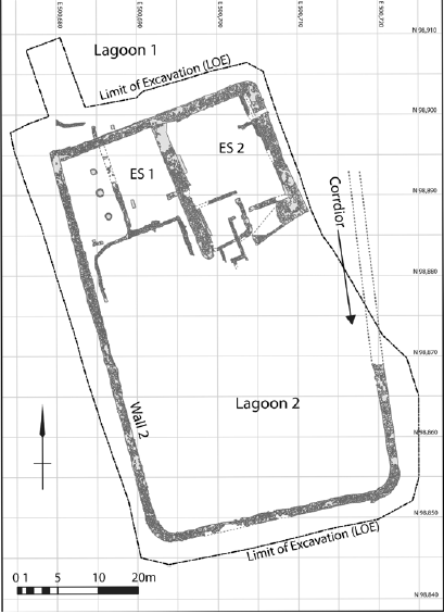
During the 2011-2012 season excavations continued at the Heit el-Ghurab site. During this season the archaeologists excavated Standing Wall Island a complex in the southern portion of the site. It is hypothesized that this site was used to corral animals. ES1 and ES2 are both rooms located within the structure. It is thought that ES1 was used as a slaughter area and ES2 was used as a processing room. The team was unable to finish excavations as the water level rose to high. The team also attempted to excavate another Gallery, which they believe is an area of barracks for sleeping, that also has an area for guards, and meal preparation. (4)
Conclusion
Through systematic excavations since 1988 archaeologists have been able to learn a lot about the site and the people who lived there. The site of Heit el-Ghurab shows the stratification of towns in Egypt even some 4000 years ago. The site covers a large amount of area, and has many different types of buildings. Galleries for eating and sleeping. Bakeries for making large amounts of bread and even some evidence of beer brewing. The western part of the town was inherently different than the eastern part, the eastern part is less organized and the western part is more likely to be an elitist area with homes for administrators and the more elite. There are many things that still need to be excavated more the area of the chute, lagoon, and royal administration building could also be excavated further.
Citations
Articles
1.Lehner, Mark. “The Pyramid Age Settlement of the Southern Mount of Egypt.” Journal for the American Research Center in Egypt 39(2002) 27-74
2.Lehner, Mark. “The Giza Plateau Mapping Project.” The Oriental Institute Annual Report (2015) 74-96
3.Lehner, Mark. “The Giza Plateau Mapping Project.” The Oriental Institute Annual Report (2012) 50-68
4.Lehner, Mark. “The Giza Plateau Mapping Project.” The Oriental Institute Annual Report (2010) 40-64
5.Lehner, Mark. “The Giza Plateau Mapping Project.” The Oriental Institute Annual Report (2006) 46-64
Images
Figure 1-Lehner, Mark. “The Giza Plateau Mapping Project.” The Oriental Institute Annual Report (2012) 51. Image by- Rebekah Miracle
Figure 2-Hawass, Zahi and Lehner, M. Builders of the Pyramids. Archaeology 50(1997) 37. Image by-Carl Andrews
Figure 3-Lehner, Mark. “The Giza Plateau Mapping Project.” The Oriental Institute Annual Report (2012) 56. Image by- Rebekah Miracle
Figure 4-Lehner, Mark. “The Giza Plateau Mapping Project.” The Oriental Institute Annual Report (2012) 52. Image by- Rebekah Miracle